NL
°F
Verander uw afmetingen
Meters
Feet
°C
°F
km/uur
mph
kts
am/pm
24-hour
Je instellingen zijn bijgewerkt
Verander de taal
Deutsch
Español
Italiano
Nederlands
中文
English
Français
日本語
Português
Vandaag
7 dagen
Weer
Vissen tijden
Zee
Getij in
United States
Getij in
Virginia
Getij in
Accomack County
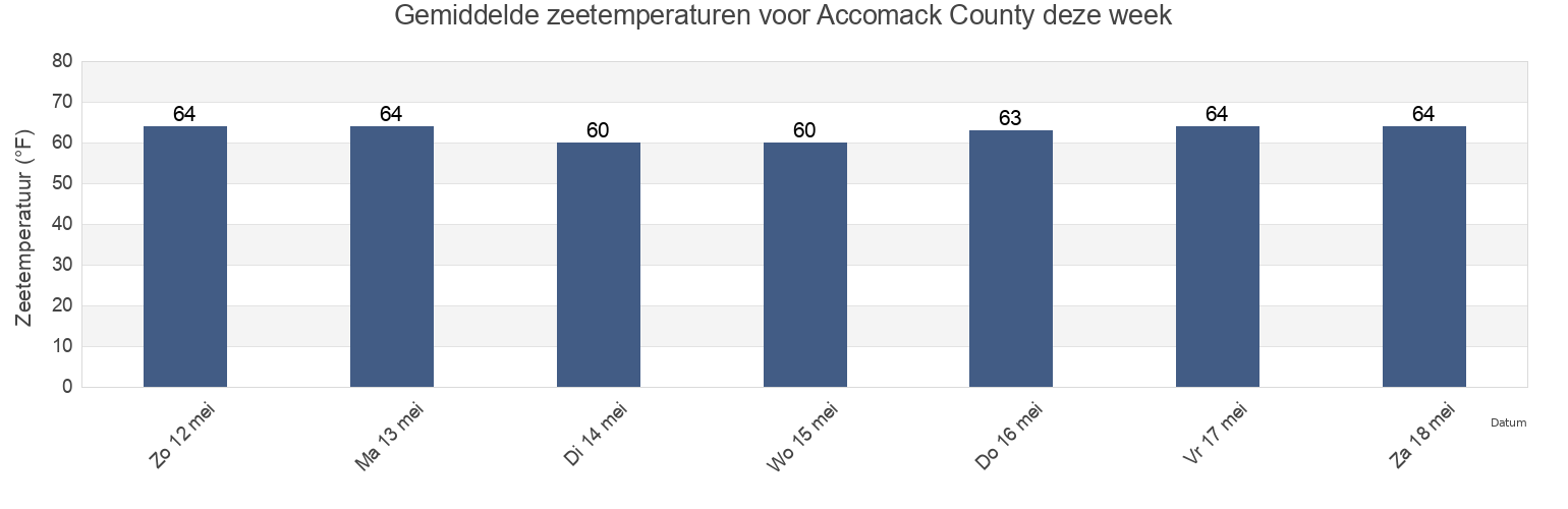
Zeetemperatuur in Accomack County
Zeetemperatuur voor Accomack County deze week
Meer getijden- en maritieme informatie voor Accomack County
Getijden vandaag
Getijden deze week
Weerbericht
Vissen tijden
Regio's en steden in Accomack County, Virginia, United States
Accomac
Milby Point 5.3 n.mi. WNW of
Tangier Sound Light 5.8 n.mi. west of
Bluff Point 7.2 n.mi. east of
Muddy Creek Entrance
The Swash
Captains Cove
Nassawadox Point 1.9 n.mi. NW of
Upshur Neck (South End)
Chesconessex Creek (Schooner Bay)
Onancock
Upshur Neck South End
Chesconessex Creek Schooner Bay
Onancock (Onancock Creek)
Wachapreague
Chincoteague
Onancock Onancock Creek
Wachapreague Inlet (inside)
Toon meer locaties
Folly Creek (Metompkin Inlet)
Pocomoke Sound Approach
Wachapreague Wachapreague Channel
Folly Creek Metompkin Inlet
Quinby Inlet entrance
Wallops Island
Gargathy Neck
Rappahannock Light
Watts Island
Gaskins Point (Occohannock Creek)
Revel Creek (Revel Island)
Watts Island 2.3 n.mi. east of
Gaskins Point Occohannock Creek
Revel Creek Revel Island
Watts Island 4 miles south of
Guard Shore
Stingray Point 12.5 miles east of
Wattsville
Harborton (Pungoteague Creek)
Tangier Island
Windmill Point Light 8.3 n.mi. ESE of
Harborton Pungoteague Creek
Tangier Sound Light 0.5 n.mi. east of
Metompkin Inlet
Tangier Sound Light 1.5 miles NE of
Getijden nabij Accomack County
Chesconessex Creek Schooner Bay
Chesconessex Creek (Schooner Bay)
Onancock Onancock Creek
Onancock
Onancock (Onancock Creek)
Watts Island 2.3 n.mi. east of
Accomac
Guard Shore
Muddy Creek Entrance
Watts Island