Getijden in Chatham County, Georgia, United States

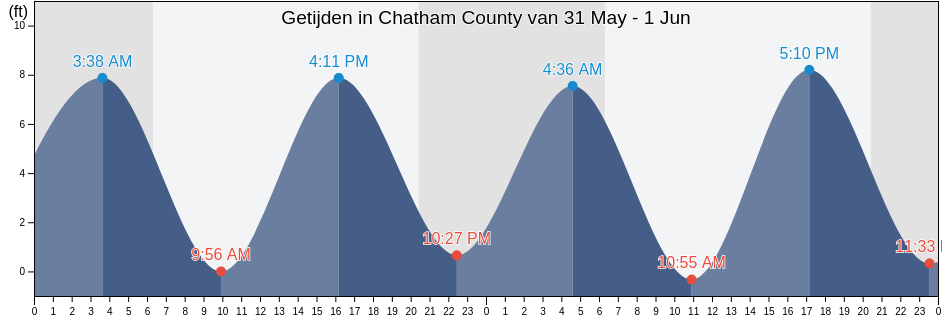
Woensdag 8 mei 2024, 07:30 EDT (GMT -0400). Het is momenteel vloed in Chatham County. Zoals je kunt zien in de getijgrafiek, is het hoogwater van 9.51ft er om 21:55 en het laagwater van -0.98ft is er om 15:40. Klik hier om de getijden tijden van Chatham County voor deze week te bekijken.

Volgende vloed

Het volgende hoogwater is om
09:34

Volgende eb

Het volgende laagwater is om
15:40

Waterstanden in Chatham County

Getijdentabel voor Chatham County deze week
Dag Waterstanden in Chatham County Zonsopkomst en zonsondergang
1ste Getij 2de Getij 3de Getij 4de Getij
wo 803:34
-0.66 ft
09:34
7.87 ft
15:40
-0.98 ft
21:55
9.51 ft
06:32 20:10
do 904:24
-0.66 ft
10:23
7.87 ft
16:27
-0.66 ft
22:42
9.19 ft
06:31 20:11
vr 1005:11
-0.33 ft
11:12
7.55 ft
17:14
-0.33 ft
23:31
8.86 ft
06:30 20:11
za 1105:58
0 ft
12:05
6.89 ft
18:01
0 ft
06:29 20:12
zo 1200:22
8.2 ft
06:45
0.66 ft
13:00
6.56 ft
18:49
0.66 ft
06:29 20:13
ma 1301:16
7.87 ft
07:33
0.98 ft
13:57
6.56 ft
19:40
0.98 ft
06:28 20:13
di 1402:11
7.22 ft
08:26
1.31 ft
14:53
6.23 ft
20:37
1.31 ft
06:27 20:14

Beste vistijden voor Chatham County vandaag Uitstekende dag om te vissen

Belangrijke vistijden

Vanaf 00:18 tot 02:18

Tegengestelde maansovergang (Maan naar beneden)

Vanaf 12:54 tot 14:54

Maansovergang (Maan omhoog)

Andere vistijden

Vanaf 06:08 tot 07:08

Maansopkomst

Vanaf 20:41 tot 21:41

Maansondergang

Klik hier om de vistijden van Chatham County voor de week te bekijken.

Het actuele weer in Chatham County

Gedeeltelijk bewolkt

Weer

Bewolking 5%
Temperatura

Temperatura

76°F
Minimaal 72°F/Maximaal 80°F
Wind

Wind

11 mph
Windstoten 19 mph
Luchtvochtigheid

Luchtvochtigheid

83%
Dauwpunt 66°F

Klik hier voor de weerbericht van Chatham County deze week

Het weer in Chatham County vandaag

De zon kwam op om 06:32 en de zonsondergang is om 20:10. Er zal 13 uur en 38 minuten zon zijn en de gemiddelde temperatuur is 76°F. Op dit moment is de huidige watertemperatuur 72°F en de gemiddelde watertemperatuur is 72°F.

Het Weer op Chatham County deze week
0 h 3 h 6 h 9 h 12 h 15 h 18 h 21 h 24 h
Gedeeltelijk bewolktGedeeltelijk bewolktGedeeltelijk bewolktGedeeltelijk bewolktGedeeltelijk bewolktGedeeltelijk bewolktGedeeltelijk bewolktGedeeltelijk bewolktGedeeltelijk bewolkt
76°F78°F76°F78°F74°F76°F76°F76°F75°F

Klik hier voor de weerbericht van Chatham County deze week

Meer getijden- en maritieme informatie voor Chatham County

Regio's en steden in Chatham County, Georgia, United States
2nd Street (Tybee Island)Fort Mcallister (Ogeechee River)Raccoon Key
610 Statute Mile MarkFort McAllister Ogeechee RiverRange A Light Bear River
Beach HammockFort PulaskiRomerly Marsh Creek
Bear River EntranceFort Pulaski 1.8 miles aboveS C L Rr Bridge
Bloody Point (Daufuskie Island)Fort Pulaski 4.8 miles aboveS.C.L. Rr. Bridge
Bloody Point Daufuskie IslandGood Hope Landing (South Of)Savannah
Bloody Pt. 0.5 mile north of New RiverGood Hope Landing South OfSavannah Bull Street
Bloody Pt. 0.5 mile west of New RiverGreys IslandSavannah River Entrance (between jetties)
Bradley Point (Bradley River)Hargray Pier (Daufuskie Island)Savannah River Entrance Fort Pulaski
Bradley Point Bradley RiverHargray Pier Daufuskie IslandSavannah Sheraton Resort Hotel
Bradley Point NNE ofHighway Bridge (Ogeechee River)Savannah southeast of highway bridge
Bull River 2 miles below hwy. bridgeHighway Bridge Ogeechee RiverSeaboard Coast Line Railroad
Burnside Island SE of Burnside RiverIsle of HopeSkidaway Island
Burntpot Island west of Skidaway RiverIsle of Hope (Skidaway River)Skidaway Island N End Wilmington River
Butter Bean BeachIsle of Hope City SE of Skidaway RiverSkidaway Narrows
Cane Patch Creek EntranceIsle of Hope City Skidaway RiverSkidaway River north entrance
Coffee Bluff (Forest River)Isle Of Hope Skidaway RiverSouth Channel western end
Coffee Bluff Forest RiverJoe's CutSouth of Kilkenny Creek Entrance
Cook Landing CemeteryJoes Cut Wilmington RiverSouth Ossabaw Island Bear River
Daufuskie Landing (Daufuskie Island)Kilkenny Club (Kilkenny Creek)St. Catherines Sound Entrance
Daufuskie Landing Daufuskie IslandKilkenny Club Kilkenny CreekThunderbolt
Daufuskie Landing Light south ofKing Island west ofThunderbolt SE of Wilmington River
Delegal Creek MarinaKings Island Channel Savannah RiverTurnbridge Landing (Salt Water Creek)
Doughboy IslandLazaretto Creek Entrance N of Bull RiverTurnbridge Landing Salt Water Creek
Dutch Island SE of Skidaway RiverLittle Back River Hwy. 17 Back River S.C.Tybee Creek Entrance
Egg IslandsLittle Don Island east of Vernon RiverTybee Island
Elba Island Cut NE of Savannah RiverLittle Ogeechee River EntranceTybee Light
Elba Island NE of Savannah RiverLittle Ogeechee River Entrance north ofTybee South End Sand Bar
Elba Island west of Savannah RiverLittle Wassaw Island SW ofVernon R. 1.2 miles S of Possum Point
Entrance off Beach HammockLong Island NNE of Skidaway RiverVernon View
Entrance off Wassaw IslandLong Island south of Skidaway RiverVernon View (Burnside River)
Fields Cut (Wright River)McQueen Island CutWalls Cut Turtle Island
Fields Cut Wright RiverMontgomeryWassaw Island N of E end Wassaw Sound
Fig Island north of Back RiverMontgomery Vernon RiverWassaw Island SSW of
Florida Passage (Bear River)North EntranceWhitemarsh Island
Florida Passage (Ogeechee River)North of Big Tom Creek EntranceWilmington Island
Florida Passage (south)Northwest of Newell Creek EntranceWilmington Island SSE of Bull River
Florida Passage Bear RiverOatland Island north tipWilmington R. 0.5 mi. S of Turners Creek
Florida Passage N of Ogeechee RiverOdingsell River EntranceWilmington R. ent. south channel
Florida Passage Ogeechee RiverPelican PointWilmington River ent. off Cabbage Island
Fort JacksonPigeon Island SSE of Skidaway RiverWright R. 0.2 mile above Walls Cut
Fort Mc Allister Ogeechee RiverPort Wentworth 0.2 mile above