NL
°F
Verander uw afmetingen
Meters
Feet
°C
°F
km/uur
mph
kts
am/pm
24-hour
Je instellingen zijn bijgewerkt
Verander de taal
Deutsch
Español
Italiano
Nederlands
中文
English
Français
日本語
Português
Vandaag
7 dagen
Weer
Vissen tijden
Zee
Getij in
United States
Getij in
Georgia
Getij in
Camden County
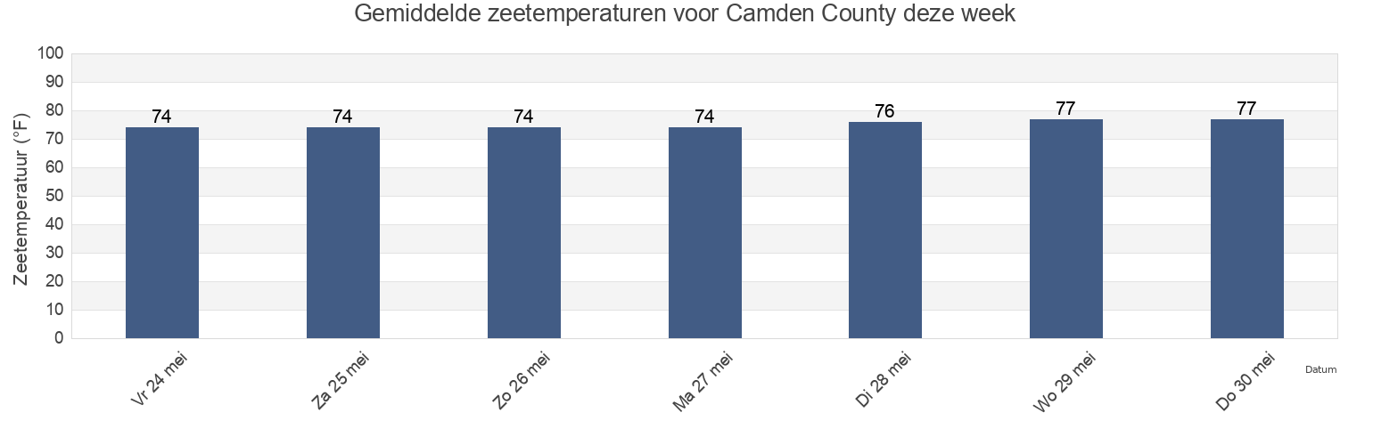
Zeetemperatuur in Camden County
Zeetemperatuur voor Camden County deze week
Meer getijden- en maritieme informatie voor Camden County
Getijden vandaag
Getijden deze week
Weerbericht
Vissen tijden
Regio's en steden in Camden County, Georgia, United States
2.5 Miles Above Mouth
Fernandina Beach Amelia River
Main Beach
Bailey Cut (0.8 Mile West Of)
Fernandina Beach City Front Reach Amelia River
Old Fernandina Amelia River Old Town Reach
Bailey Cut 0 8 mile west of
Fernandina Pier
Quarantine Reach 0.4nm W of Fort Clinch
Bailey Cut Satilla River
Floyd Creek (2.8 Miles Above Entrance)
Raccoon Key Spit
Beach Creek Ent. (Cumberland Island)
Floyd Creek 2.8 Miles Above Entrance
Roses Bluff (Bells River)
Cabin Bluff Cumberland River
Fort Clinch 0.3 n.mi. N of
Roses Bluff Bells River
Toon meer locaties
Ceylon
Fort Clinch 1.1 n.mi. NW of
Saint Marys
Chester (Bells River)
Harrietts Bluff (Crooked River)
Seacamp Dock (Cumberland Island)
Chester Bells River
Harrietts Bluff Crooked River
Seacamp Dock Cumberland Island
Comfort Inn/Jeckyll Island
Jekyll Creek south entrance
Seals
Comfort Inn/Jekyll Island
Jekyll Island Marina (Jekyll Creek)
south jetty
Crandall
Jekyll Island Marina Jekyll Creek
St Marys
Crooked River (Cumberland Dividings)
Jekyll Point, Jekyll Sound
St Marys Entrance North Jetty
Crooked River Cumberland Dividings
Kings Bay (Navy Base)
St. Marys
Cumberland Island Range B Channel
Kings Bay Base
St. Marys Entrance (North Jetty)
Cumberland River north entrance
Kings Bay Lower Turning Basin
St. Marys Entrance North Jetty
Cumberland Wharf (Cumberland River)
Kings Bay Navy Base
St. Marys River Entrance
Cumberland Wharf Cumberland River
Kings Bay NSB
Stafford Island west of
Cut 1 N Front Range St Marys River Entr
Kingsley Creek
Todd Creek Entrance
Dover Bluff (Dover Creek)
Kingsley Creek highway bridge
U S Highway 17
Dover Bluff Dover Creek
Kingsley Creek RR bridge
Drum Point Island Range D Channel
Little Satilla River
Getijden nabij Camden County
Ceylon
Harrietts Bluff Crooked River
Harrietts Bluff (Crooked River)
Bailey Cut 0 8 mile west of
Bailey Cut (0.8 Mile West Of)
Bailey Cut Satilla River
Seals
Floyd Creek 2.8 Miles Above Entrance
Floyd Creek (2.8 Miles Above Entrance)
Cabin Bluff Cumberland River