Getijden in Charleston County, South Carolina, United States

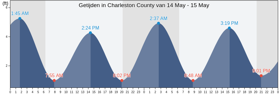
Donderdag 25 april 2024, 08:26 EDT (GMT -0400). Het is momenteel vloed in Charleston County. Zoals je kunt zien in de getijgrafiek, is het hoogwater van 5.91ft er om 22:16 en het laagwater van 0.33ft was er om 03:53. Klik hier om de getijden tijden van Charleston County voor deze week te bekijken.

Volgende vloed

Het volgende hoogwater is om
09:50

Volgende eb

Het volgende laagwater is om
15:46

Waterstanden in Charleston County

Getijdentabel voor Charleston County deze week
Dag Waterstanden in Charleston County Zonsopkomst en zonsondergang
1ste Getij 2de Getij 3de Getij 4de Getij
do 2503:53
0.33 ft
09:50
4.92 ft
15:46
0.33 ft
22:16
5.91 ft
06:38 19:58
vr 2604:33
0.33 ft
10:24
4.59 ft
16:22
0.33 ft
22:54
5.91 ft
06:37 19:58
za 2705:14
0.66 ft
11:03
4.59 ft
17:01
0.33 ft
23:36
5.91 ft
06:36 19:59
zo 2806:00
0.66 ft
11:48
4.59 ft
17:47
0.66 ft
06:35 20:00
ma 2900:26
5.58 ft
06:50
0.66 ft
12:42
4.59 ft
18:41
0.66 ft
06:34 20:00
di 3001:24
5.58 ft
07:47
0.66 ft
13:46
4.59 ft
19:46
0.66 ft
06:33 20:01
wo 102:27
5.58 ft
08:47
0.66 ft
14:55
4.59 ft
20:56
0.66 ft
06:32 20:02

Beste vistijden voor Charleston County vandaag Goede dag om te vissen

Belangrijke vistijden

Vanaf 08:25 tot 10:25

Tegengestelde maansovergang (Maan naar beneden)

Vanaf 20:57 tot 22:57

Maansovergang (Maan omhoog)

Andere vistijden

Vanaf 06:52 tot 07:52

Maansondergang

Vanaf 21:27 tot 22:27

Maansopkomst

Klik hier om de vistijden van Charleston County voor de week te bekijken.

Het actuele weer in Charleston County

Gedeeltelijk bewolkt

Weer

Bewolking 10%
Temperatura

Temperatura

66°F
Minimaal 64°F/Maximaal 71°F
Wind

Wind

7 mph
Windstoten 11 mph
Luchtvochtigheid

Luchtvochtigheid

78%
Dauwpunt 57°F

Klik hier voor de weerbericht van Charleston County deze week

Het weer in Charleston County vandaag

De zon kwam op om 06:38 en de zonsondergang is om 19:58. Er zal 13 uur en 20 minuten zon zijn en de gemiddelde temperatuur is 68°F. Op dit moment is de huidige watertemperatuur 63°F en de gemiddelde watertemperatuur is 63°F.

Het Weer op Charleston County deze week
0 h 3 h 6 h 9 h 12 h 15 h 18 h 21 h 24 h
Gedeeltelijk bewolktGedeeltelijk bewolktGedeeltelijk bewolktGedeeltelijk bewolktDichtbij onregelmatige regenDichtbij onregelmatige regenGedeeltelijk bewolktDichtbij onregelmatige regenGedeeltelijk bewolkt
67°F69°F66°F69°F70°F69°F66°F66°F66°F

Klik hier voor de weerbericht van Charleston County deze week

Meer getijden- en maritieme informatie voor Charleston County

Regio's en steden in Charleston County, South Carolina, United States

Abbapoola Creek EntranceFolly River (North Folly Island)Patriots Point
ACE BasinFolly River Bridge (Flooy Island)Pea Island
Army DepotFolly River Bridge Flooy IslandPennys Creek (West Entrance)
Ashley River (I-526 Bridge)Folly River North Folly IslandPennys Creek West Entrance
AwendawFort JohnsonPleasant Point
Battery southwest ofFort SumterPlum Island
Bees Ferry BridgeFort Sumter Range Buoy 14Point Of Pines
Ben Sawyer BridgeFort Sumter Range Buoy 2Price Creek (North Capers Island)
Ben Sawyer Bridge ICWWFort Sumter Range Buoy 20Price Creek North Capers Island
Big Paradise IslandFort Sumter Range Buoy 4Rathall Creek entrance
Bluff PointFort Sumter Range Buoy 8Rebellion Reach 0.8 n.mi. N. of Ft. Sumter
Botany Bay IslandFt. Sumter 0.6 n.mi. NW ofRemley Point 0.2 mile northwest of
Bowen IslandGoose Creek entranceRockville (Bohicket Creek)
Breach Inlet (Isle Of Palms)Goshen Point SE of Wadmalaw RiverRockville Bohicket Creek
Breach Inlet Isle Of PalmsGoshen Point south of Wadmalaw RiverS.C.L. RR. bridge 0.1 mile below
Buck Hall (Awendaw Creek)Hamlin Creek (Isle Of Palms)S.C.L. RR. bridge 1.5 miles above
Buck Hall Awendaw CreekHamlin SoundSandblasters (Pennys Creek)
Buoy '19'Harbor River EntranceSandblasters Pennys Creek
Buoy 19 off Nowell CreekHo-non-wah Boy Scout Camp (Bohicket Creek)Seabrook Beach
CainhoyHobcaw PointSeabrook Island
Cainhoy Wando RiverHog Island ChannelSecessionville Secessionville Creek
Capers Creek South Capers IslandHog Island Reach Buoy 12Shem Creek
Castle Pinckney 0.4 mile south ofHog Island Reach SW of Remley PointShipyard Creek (0.8 mile above entrance)
Castle Pinckney 0.6 mile southwest ofHollywoodShipyard Creek entrance
CharlestonHorlbeck Creek 0.2 mile above entranceShutes Folly Island 0.4 mile west of
Charleston (customhouse Wharf)Horlbeck Creek 2.5 miles north ofShutes Reach Buoy 8
Charleston Harbor (off Fort Sumter)Horse ReachSnake Island
Charleston Harbor EntranceI 526 BridgeSol Legare Island
Charleston Hbr. ent. (between jetties)Isle of PalmsSouth Ashley Bridge
Church Creek BridgeIsle Of Palms PierSouth Capers Island
Church FlatsJack Creek EntranceSouth Chan. 0.4 mi. NW of Ft. Johnson
Clouter Creek (North Entrance)James Island Creek (1 mi. above ent.)South Chan. 0.8 mi. ENE of Ft. Johnson
Clouter Creek (South Entrance)Johns Island (Church Creek)South Channel Buoy 32
Clouter Creek North EntranceJohns Island Airport south ofSouth Dewees Island (Dewees Inlet)
Clouter Creek South EntranceJohns Island BridgeSouth Dewees Island Dewees Inlet
Cosgrove BridgeJohns Island Church CreekSouth Jetty break in
Customhouse ReachKiawah IslandState Hwy. 7 bridge
Customhouse Reach off CustomhouseKiawah River BridgeStono Inlet
Daniel Island BendLeadenwah Creek (3 Mi. Above Entrance)Sullivans I. 0.7 mi. NE of Ft. Sumter
Daniel Island ReachLimehouse BridgeSullivans Island
Daniel Island Reach Buoy 48MeggettSullivans Island (outer Coast)
Deveaux Banks off North Edisto River entranceMoores Landing (Sewee Bay)The Cove (Fort Moultrie)
Drayton Bees FerryMoores Landing ICWW Sewee BayThe Cove entrance on the Cove Range
Drum Island 0.2 mile aboveMorris IslandThe Cove Fort Moultrie
Drum Island 0.4 mile SSE ofMount PleasantThe Washout
Drum Island east of (bridge)North CharlestonTown Creek 0.2 mile above bridge
Drum Island Reach off Drum I. Buoy 45North Dewees Island (Capers Inlet)Town Creek Lower Reach
Duck IslandNorth Dewees Island Capers InletWadmalaw Island Wadmalaw River entrance
Elliott Cut EntranceNorth Edisto River entranceWando River Upper Reach Turning Basin
Elliott Cut west endNorth Jetty 0.8 mile southeast ofWappoo Creek
Filbin Creek ReachNowell CreekWappoo Creek Highway Bridge
Filbin Creek Reach 0.2 mile east ofNowell Creek entranceWappoo Creek off of
Filbin Creek Reach Buoy 58Oak Branch (Bohicket Creek)West Marsh Island 0.1 mile east of
Five Fathom Creek EntranceOak Branch Bohicket CreekWharf Creek Entrance
Folly BeachOcella Creek (2 Mi. Above Entrance)Woods Point
Folly Beach PierOld Capers Landing (Capers Island)Woods Point SE of
Folly Creek (Hwy. 171 Bridge)Old Capers Landing Santee Pass Capers IslandWoodville
Folly I. Channel N of Ft. JohnsonOrdnance ReachYellow House Creek
Folly Island (outer Coast)Parker Island (Horlbeck Creek)Yellow House Landing 1 mile NW of
Folly Reach Buoy 5Parker Island Horlbeck CreekYonges Island